 |
| Arrival at Whitby on Sunday, after 247 nautical miles! |
Imray's chart, C29, is entitled 'Harwich to Whitby'. So I did! It seemed like a worthy challenge... and, as East Coast Representative for the Drascombe Association, I thought I ought to explore a little more of the area.
 |
| 247nm (est.) |
Of course, there was nothing impulsive about this trip - it had been long in the planning and much of the summer holiday was spent awaiting favourable winds and tides. I had intended to go a fortnight or so earlier, but the weather had been far too windy to contemplate long days out at sea, particularly for the planned trip across The Wash. Fortunately, things fell into place for this week and the opportunity was not to be missed.
Day 1: Sunday 20th August, River Orwell to Southwold
Today's destination was flexible - Southwold or Lowestoft. Lowestoft would cut the sea hours the following day, Southwold is far more picturesque. In the event, I opted for the nearer port knowing that this would most likely add a day to the journey. I wanted to reach Wells before contemplating a trip across The Wash and it would just be a step too far to make Wells from Southwold in one day.
I launched at Woolverstone Marina just before HW (11am) having arranged to leave car and trailer here until my return a week later. Winds were light and I found myself using the engine more than I would have liked for the trip up the coast. The ebbing tide would be with me for much of the trip, at least until Aldeburgh.
 |
| Military hangers off Orford. |
 |
| Orford Ness lighthouse |
The tide did indeed turn at some point off the nuclear power station at Sizewell. Sails were dropped, and I motored for port. Even though Southwold was visible in the distance, it took several hours of motoring to reach port. Tide was still in the early flood at this stage, and tidal currents in the River Blyth had still to reach their peak, which made mooring much easier.
 |
| Secure on the new visitor's jetty at Southwold - a fine facility. |
 |
| Day 1: River Orwell to Southwold, 36.5nm |
Day 2: Monday 21st August, Southwold to Blakeney
This was going to be an exceptionally long day at sea. I departed from Southwold at 0500, knowing that the tide wouldn't turn in my favour for at least another four hours. There is a considerable difference. A favourable tide means speeds of 6+ knots with a modest power input; tides against mean speeds of just over 3 knots with considerable power input. The calculation today was that I would have a full 6 hours of favourable tides and this needed to be exploited to the full to reach Blakeney harbour.
 |
| Leaving Southwold. It was actually considerably darker than this; the sun was about to rise and Southwold, from the north east, was covered in a blanket of mist. |
 |
| Sunrise at sea is always a treat. |
 |
| I took a series of snaps of erosion, knowing that the media has made much of the loss of land and buildings along this stretch of coast. The evidence was clear to see. |
At a point between Winterton and Sea Palling, I was directed a couple of miles away from shore whilst several large tugs and ships conducted a salvage operation for several 500m lengths of floating piping.
 |
| Floating piping out at sea. |
The tide turned in my favour soon after passing Great Yarmouth. I had made great use of engine up to that point. Thereon, I enjoyed a lengthy stretch of pleasant F3/4 winds under sail until Cromer when the wind dropped.
 |
| Cromer |
 |
| Sheringham |
I needed to be at Blakeney Bar by 1930 HW which was managed. However, a few hours prior to HW, the tide along the coast sets in an easterly direction. So the final three hours were made with the help of the outboard. It was questionable as to whether I could have continued to Wells. I probably might have managed it, but light was already beginning to fade, and I fancied a look in Blakeney harbour, picking up one of several vacant moorings for the night after 14.5 hours of non-stop motion!
 |
| Southwold to Blakeney: 62.1nm |
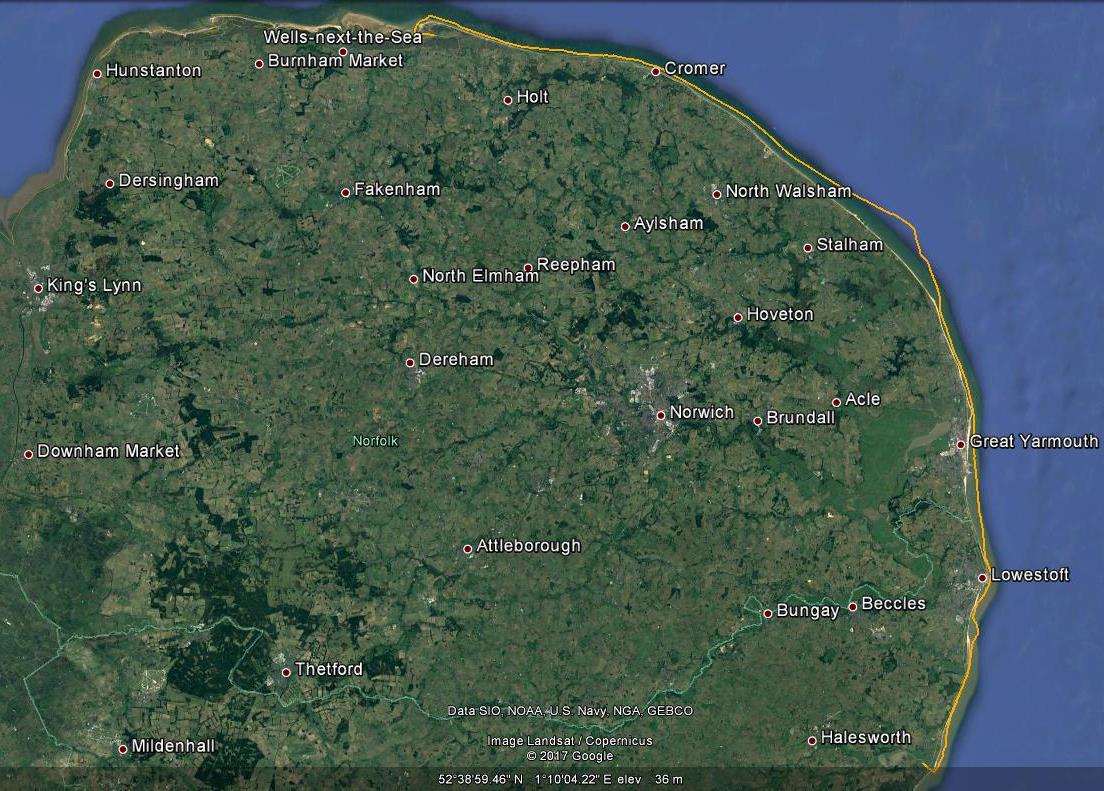
Day 3: Tuesday 22nd August, Blakeney to Wells-next-the-Sea
The considerable exertions of the previous day had taken their toll. The best thing for today was to hop round to Wells and spend the day there, restocking and planning before the next anticipated long haul across The Wash to The Humber.
I left Blakeney probably later than intended and slightly underestimated the relatively short trip to Wells, nevertheless making it by about 90 minutes after HW. I was against the tide all the way and was heartily relieved to tie up, as instructed by the Deputy Harbour Master, next to a fishing boat on the pontoon at Wells.
 |
| Seals off Blakeney Point |
Once at Wells, I was able to recharge the battery (literally), and replenish supplies, particularly by setting off on a long trip by foot to the nearest petrol station, which it turns out is 5 miles away. Fortunately, kind members of the public took pity on me both ways and I probably walked only about half of the 10 mile round trip - and had plenty of blackberry stops along the way, as well as a lovely pub lunch in the village of Binham. Still, I had all day in which to achieve this, and it was a splendid day with virtually no wind. However, why Wells itself doesn't merit a petrol station, we shall never understand.
 |
| In the evening, several fishing boats returned including one lowlife skipper whose wash pushed a whole load of sandy scum all over Daisy II's bows and on the cabin top. This picture was taken after spending much time attempting to clear things up... |
 |
| Blakeney Harbour to Wells-next-the-Sea, 9.2nm |
Day 4: Wednesday 23rd August, Wells-next-the-Sea to Tetney Haven (River Humber)
This was always going to be the most arduous passage of the trip. In retrospect, I chose a silly route in steering away from shore. I should have followed initial instincts which had been to work a passage over to somewhere close to Skegness, avoiding the several wind farms of course, and then up the coast. It's a lonely place, out at sea with no land in sight and The Wash presents tricky conditions. Today, a relatively light, but nonetheless noticeable south-easterly made for some very rocky seas, and visibility was poor. Once away from Wells, I didn't spot land again until entering the firing range off Donna Nook, close to the intended destination.
To cap off a difficult day, the GPS kept cutting out, something I subsequently gathered may well have been a loose connection at the positive terminal on the ship's battery - but I didn't spot that until a few days later...
Anyhow, today was not a day for photographs until close to Tetney Haven itself - an anchorage which most certainly didn't disappoint. In fact, I was mightily impressed by The Humber in general, and look forward to returning one day for a longer cruise in this area.
 |
| Inner Dowsing navigation marker |
 |
| Haile Sand Fort, River Humber - a welcome sight since, the area to the rear right of the picture is Tetney Haven, my intended anchorage for the night. |
Tetney Haven itself didn't disappoint and provided a welcome sanctuary. Arriving, as I had planned, near to HW, I found, easily enough, the strange channel into the haven, as described by Henry Irving in his excellent Imray publication:
Tidal Havens of The Wash and Humber. Eventually, I cast anchor in the middle of the dozen or so moorings from the yacht club here, having accepted advice from a local yachtsman. The thing that was most noticeable was the roar of the tide as it subsequently left the Humber. In our sanctuary, we were protected by a high bank of sand known locally as
The Whaleback. Drying out, it was another pleasant, still night of sleep.
 |
| After four days out at sea, the ship's fridge ceases to be effective, so I have to forage in the lower locker areas for sources of potential food... Still, OSH doesn't hurt... |
 |
| Wells-next-the-Sea to Tetney Haven, River Humber: 52.8nm |
Day 5: Thursday 24th August, Tetney Haven to Bridlington
Yesterday's was the most difficult passage. Today, once having negotiated my way across the mouth of The Humber and clear of Spurn Point, the excellent weather forecast offered reason for much optimism for the final two legs of the journey. I set off at HW 0830, intending to reach Bridlington by about 1800 which would be about an hour before its HW.
It is difficult working across the several shipping lanes at the mouth of the Humber. As ever, ships which seem miles away suddenly approach in full view just as one sets across their path. I cut things a little fine negotiating my way across the final shipping channel today, but made it just. Then, it is necessary to steer a wide berth around Spurn Point due to challenging eddies. The trip up the coast, however, was truly splendid. Westerly winds were pushing me further and further out to sea whilst under sail. So, once clear of the two wind farms in this region, I furled sails and motored back to shore before setting sail once again for Bridlington harbour.
 |
| Approaching Bridlington under sail - full main with reefed jib. |
 |
| Safely moored at Bridlington - an excellent harbour with good facilities. |
 |
| This turned out to be quite atmospheric, as a shot taken early the following morning. The reason for taking it, though was the image of the rusting fishing vessel to the right which was named Budding Rose. Yes, we're in Yorkshire, and that is Yorkshire humour...! |
 |
| Tetney Haven (on The Humber) to Bridlington: 46.7nm |
Day 6: Friday 25th August, Bridlington to Whitby
And so it came down to the final day. Winds were, again, light and westerly/south westerly.
I set off at around 0800, an hour or so before HW. The tide was already helping me on my way, and I had an inspiring couple of hours looking, close in, at 'nature's cathedral' - the several miles of cliffs, stacks, buttresses and caves which constitute Flamborough Head.
 |
| The inspiring Flamborough Head - nature's cathedral! |
Thereafter, I swept in as close as I dared to Filey Brigg, and then even closer in to Scarborough. Winds had been very helpful up to this point, but dwindled somewhat as I approached Robin Hood Bay, by which time the tide had also turned against me, so I motored the final 6 miles or so to the destination of Whitby, as photographed at the head of this post.
Once inside Whitby harbour, I had to wait half an hour before Whitby bridge became operative two hours before HW, and then found my way to Whitby Marina for the night.
 |
| Whitby Marina |
 |
| Bridlington to Whitby: 39.8nm |
This wasn't, of course, quite the end of the excitement. I needed to use public transport back to home in Cambridgeshire, and then was driven back to Ipswich to pick up car and trailer. The next day (Sunday), I drove the trailer up to Whitby early in the morning and took
Daisy II out of the water close to HW at the excellent slipway adjacent to the marina, prior to driving back home.
I've made it to Whitby. What next? Well, another summer, another challenge: Whitby onwards! The Tyne and Lindsfarne sound appealing. Moreover, having holidayed there previously, I have an ambition to make it over The Forth to Anstruther in East Fife!


Wow, all very impressive, so glad you were able to make it. Interesting to read your blog. Thanks.
ReplyDeleteThanks Mum!
DeleteA very pleasant read Julian..............almost makes me feel like finding my own sea legs! I look forward to the next instalment.....
ReplyDeleteThank you Paul. I would do it all again tomorrow if I could....!
Delete